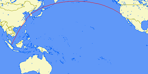
Today I solved a mystery. During my flights I always observed the in-flight display showing the flight route. And during my flights to the States, I always wonder why the flight route was an arc towards Russia and Alaska instead of flying straight across the Pacific ocean.
Wouldn’t that be more expensive & time-consuming to fly a longer route? Flying closer to land for safety and emergency? Airspace issues? Wind support in the route to fly faster?
In fact, the plane was flying the shortest route, just that the line became curved when shown on a flat map. The phenomenon is called the Great Circle. I managed to find a Great Circle Mapper, and plotted the route from SIN to SFO.
Presto! Adding the fact that I had to stop over at ICN or HKG, the path became so much like the ones I took. It also means if there was a camera looking at me here facing SFO, and zoomed out of Earth so much that I could see the straight-line route on the globe surface, I would actually see Alaska along the way! I couldn’t have imagined it since my mind was stuck with the regular flat map. (and I wonder if anyone else understands what I am describing…)
Now I’m satisfied I actually took the shortest distance.
